- TRANSDUCERS
- TRANSDUCERS
- BASIC COMPONENTS DK
- BASIC COMPONENTS DK
- MARKETPLACE
- MARKETPLACE
- DEVELOPMENT BOARDS & KITS
- DEVELOPMENT BOARDS & KITS
- CABLE ASSEMBLIES
- CABLE ASSEMBLIES
- RF AND WIRELESS
- RF AND WIRELESS
- BOXES ENCLOSURES RACKS
- BOXES ENCLOSURES RACKS
- AUDIO PRODUCTS
- AUDIO PRODUCTS
- FANS-BLOWERS-THERMAL MANAGEMENT
- FANS-BLOWERS-THERMAL MANAGEMENT
- WIRELESS MODULES
- WIRELESS MODULES
- TERMINALS
- TERMINALS
- Cables/Wires
- Cables/Wires
- SINGLE BOARD COMPUTER
- SINGLE BOARD COMPUTER
- BREAKOUT BOARDS
- BREAKOUT BOARDS
- LED
- LED
- TEST AND MEASUREMENT
- TEST AND MEASUREMENT
- DEVELOPMENT BOARDS AND IC's
- DEVELOPMENT BOARDS AND IC's
- EMBEDDED COMPUTERS
- EMBEDDED COMPUTERS
- OPTOELECTRONICS
- OPTOELECTRONICS
- INDUSTRAL AUTOMATION AND CONTROL
- INDUSTRAL AUTOMATION AND CONTROL
- COMPUTER EQUIPMENT
- COMPUTER EQUIPMENT
- CONNECTORS & INTERCONNECTS
- CONNECTORS & INTERCONNECTS
- MAKER/DIY EDUCATIONAL
- MAKER/DIY EDUCATIONAL
- TOOLS
- TOOLS
- MOTORS/ACTUATORS/SOLEENOIDS/DRIVERS
- MOTORS/ACTUATORS/SOLEENOIDS/DRIVERS
- FPGA HARDWARE
- FPGA HARDWARE
- ROBOTICS & AUTOMATION
- ROBOTICS & AUTOMATION
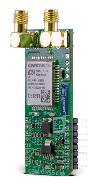
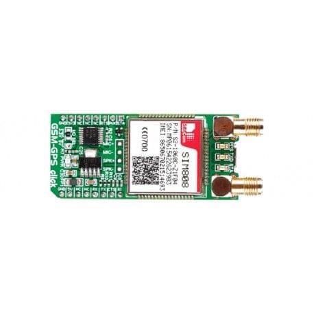
GSM/GNSS click combines GPS/GLONASS location tracking with GSM module capability for mobile communication. The click features Quectel’s MC60 quad-band module. GSM/GNSS click runs on either 3.3V or 5V power supply and communicates with the target MCU over UART interface, and the following mikroBUS™ pins: AN, RST, PWM, INT.
When connected to a GPS antenna, it can receive GPS coordinates, time, and other information from orbiting satellites. The click can be used for all GSM functions — calls, messages (SMS, MMS), mobile internet.
GSM/GNSS click has an onboard MicroSD card socket, micro SIM card socket, a Bluetooth antenna (the MC60 module supports Bluetooth 3.0) and additional pins for connecting speakers and a microphone.
Quectel’s MC60 quad-band module
MC60 is a quad-band full-featured GSM/GPRS module using LCC castellation package. With an extensive set of internet protocols (TCP, UDP, PPP, FTP, HTTP and SSL*), it has integrated GNSS technology for satellite navigation.
The module can balance between positioning accuracy and power consumption according to the environmental and motion conditions. The typical power consumption is around 2.8mA.
Positioning — EASY™ technology
EASY™ is the abbreviation of Embedded Assist System for quick positioning. With EASY™ technology, MC60’s GNSS engine can automatically calculate and predict orbits using the ephemeris data (up to 3 days) when the power is on, and then save that information into the memory.
The GNSS engine can use this information for later positioning, if there is not enough information from the satellites.
GPS and GLONASS
GNSS stands for Global Navigation Satellite System, an umbrella term that describes both the United States GPS and the Russian GLONASS global positioning systems. GLONASS is an acronym for Globalnaya Navigatsionnaya Sputnikovaya Sistema (Global Navigation Satellite System).
GPS currently has 33 satellites in orbit, and GLONASS has 24. This two-constellation system is particularly suitable for urban areas with high-rise buildings and complex environments.
GLONASS is suited for usage in high latitudes (north or south), where getting a GPS signal can be difficult.
Application
Asset tracking, for navigation devices based on GPS and GLONASS, road navigation devices, public transport, wearable devices, etc.
Specifications
| Type | GPS,GSM |
| Applications | Asset tracking, for navigation devices based on GPS and GLONASS, road navigation devices, public transport, wearable devices, etc. |
| Key Features | MC60 quad-band module, GPS/GNSS location tracking, UART interface, 3.3V or 5V power supply |
| Key Benefits | GPS, GNSS, GSM, and Bluetooth in one click |
| Interface | UART,GPIO |
| Input Voltage | 3.3V or 5V |
| Compatibility | mikroBUS |
| Click board size | L (57.15 x 25.4 mm) |
- Home
- DEVELOPMENT BOARDS AND IC's
- MIKROELECTRONICA
- GSM/GNSS click
GSM/GNSS click
SIZE GUIDE
Your enquiry has been sent
Product Enquiry Form
Leave us a message for futher information.
- Shipping in 10-12 Working days
Description of product
GSM/GNSS click combines GPS/GLONASS location tracking with GSM module capability for mobile communication. The click features Quectel’s MC60 quad-band module. GSM/GNSS click runs on either 3.3V or 5V power supply and communicates with the target MCU over UART interface, and the following mikroBUS™ pins: AN, RST, PWM, INT.
When connected to a GPS antenna, it can receive GPS coordinates, time, and other information from orbiting satellites. The click can be used for all GSM functions — calls, messages (SMS, MMS), mobile internet.
GSM/GNSS click has an onboard MicroSD card socket, micro SIM card socket, a Bluetooth antenna (the MC60 module supports Bluetooth 3.0) and additional pins for connecting speakers and a microphone.
Quectel’s MC60 quad-band module
MC60 is a quad-band full-featured GSM/GPRS module using LCC castellation package. With an extensive set of internet protocols (TCP, UDP, PPP, FTP, HTTP and SSL*), it has integrated GNSS technology for satellite navigation.
The module can balance between positioning accuracy and power consumption according to the environmental and motion conditions. The typical power consumption is around 2.8mA.
Positioning — EASY™ technology
EASY™ is the abbreviation of Embedded Assist System for quick positioning. With EASY™ technology, MC60’s GNSS engine can automatically calculate and predict orbits using the ephemeris data (up to 3 days) when the power is on, and then save that information into the memory.
The GNSS engine can use this information for later positioning, if there is not enough information from the satellites.
GPS and GLONASS
GNSS stands for Global Navigation Satellite System, an umbrella term that describes both the United States GPS and the Russian GLONASS global positioning systems. GLONASS is an acronym for Globalnaya Navigatsionnaya Sputnikovaya Sistema (Global Navigation Satellite System).
GPS currently has 33 satellites in orbit, and GLONASS has 24. This two-constellation system is particularly suitable for urban areas with high-rise buildings and complex environments.
GLONASS is suited for usage in high latitudes (north or south), where getting a GPS signal can be difficult.
Application
Asset tracking, for navigation devices based on GPS and GLONASS, road navigation devices, public transport, wearable devices, etc.
Specifications
| Type | GPS,GSM |
| Applications | Asset tracking, for navigation devices based on GPS and GLONASS, road navigation devices, public transport, wearable devices, etc. |
| Key Features | MC60 quad-band module, GPS/GNSS location tracking, UART interface, 3.3V or 5V power supply |
| Key Benefits | GPS, GNSS, GSM, and Bluetooth in one click |
| Interface | UART,GPIO |
| Input Voltage | 3.3V or 5V |
| Compatibility | mikroBUS |
| Click board size | L (57.15 x 25.4 mm) |
NEWSLETTER
Subscribe to get Email Updates!
Thanks for subscribe.
Your response has been recorded.
INFORMATION
ACCOUNT
ADDRESS
Tenet Technetronics# 2514/U, 7th 'A' Main Road, Opp. to BBMP Swimming Pool, Hampinagar, Vijayanagar 2nd Stage.
Bangalore
Karnataka - 560104
IN
Tenet Technetronics focuses on “Simplifying Technology for Life” and has been striving to deliver the same from the day of its inception since 2007. Founded by young set of graduates with guidance from ardent professionals and academicians the company focuses on delivering high quality products to its customers at the right cost considering the support and lifelong engagement with customers. “We don’t believe in a sell and forget model “and concentrate and building relationships with customers that accelerates, enhances as well as provides excellence in their next exciting project.


